


Blank Map of Europe 100 x 70cm + interactive
9.00€
The blank map of Europe that can be displayed in the classroom to impart a lasting understanding of the europe in your geography lessons. It is ideal for children, and will provide their learning with visual support, developing their ability to locate countries on the map. It includes Velcro fasteners that you can attach on different points to play games with the students.
You will also receive a link to access the digital and interactive versions of the map through the free app Genially. You will have several digital versions of the map to choose from, interactive maps and challenges It includes:
A PRINTED BLANK MAP OF EUROPE 100 cm x 70cm, to display in the classroom
- Blank Map of Europe 100cm x 70cm + 45 ROUND VELCROS TO USE ON THE MAP
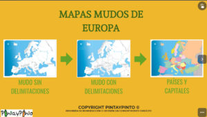
Online Blank Maps of Europe, A4 size to print in school or home
- Blank map of Europe with mountain ranges, rivers, countries and their capitals.
- White map or Europe, only with mountain ranges and rivers.
- Blank map of europe, with only countries and capitals in color
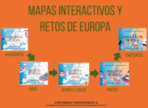
Interactive maps, with extra content and brief explanations
- Interactive map of Europe, with names of the main rivers, seas, ocean and main islands with a brief description. *
- Interactive map with mountain ranges, main peaks and landforms. *
- Interactive map of countries in Europe
- Interactive map of european capitals
Interactive challenges, to reinforce your knowledge at home.
- Interactive challenge european geography
- European rivers challenge. *
- Seas and islands of Europe challenge. *
- European countries challenge. *
- European cities challenge. *
The product license is annual and runs from September to September
Description
The blank map of Europe that can be displayed in the classroom to impart a lasting understanding of the europe in your geography lessons. It is ideal for children, and will provide their learning with visual support, developing their ability to locate countries on the map. It includes Velcro fasteners that you can attach on different points to play games with the students.
You will also receive a link to access the digital and interactive versions of the map through the free app Genially. You will have several digital versions of the map to choose from, interactive maps and challenges It includes:
A PRINTED BLANK MAP OF EUROPE 100 cm x 70cm, to display in the classroom
- Blank Map of Europe 100cm x 70cm + 45 ROUND VELCROS TO USE ON THE MAP
Online Blank Maps of Europe, A4 size to print in school or home
- Blank map of Europe with mountain ranges, rivers, countries and their capitals.
- White map or Europe, only with mountain ranges and rivers.
- Blank map of europe, with only countries and capitals in color
Interactive map of Europe, with extra content and brief explanations
- Interactive map of Europe, with names of the main rivers, seas, ocean and main islands with a brief description. *
- Interactive map with mountain ranges, main peaks and landforms. *
- Interactive map of countries in Europe
- Interactive map of european capitals
Interactive quiz of European countries, to reinforce your knowledge at home.
- Interactive challenge european geography
- European rivers challenge. *
- Seas and islands of Europe challenge. *
- European countries challenge. *
- European cities challenge. *
The product license is annual and runs from September to September
This blank map of European countries is a very flexible tool. It can be used in many subjects, mainly geography and history, but also in m any other like languages, even mathematics. The white map of Europe can be used as: – physical map of Europe, to identify geographical features like mountains, plains, capes, gulfs, rivers, lakes, seas, etc. – political map of Europe, to identify, countries, capitals, borders, etc
Here are a few ideas of how they could be used:
- Political map of Europe (countries, capitals, borders,…)
- Physical map (Main rivers, mountain ranges, peaks, gulfs, headlands …). On the map are the main rivers in Europe and some tributaries. If you want to study an area in greater depth, you can add more rivers (drawing them for example) and even add mountains or peaks. We provide a selection of mountains for you to print and use. You will receive this extra content by e-mail once the order has been processed.
- Climates
- Endangered species
- Fauna and Flora
- Dinosaurs
- Flags
- Demography
- National parks
- Mathematical problems using the map scale and distances.
- Present any topic in Spanish or French …
Different historical eras:
- Prehistory
- war conflicts
- Europe during the Roman Empire
If we work with different historical eras, one idea is for each group of students to research and present that period on the map. It is great for teamwork and presentation skills.
This method can be done with any period in history, even prehistory.
Additional information
| Weight | 0.2 kg |
|---|
Reviews
There are no reviews yet.